 |
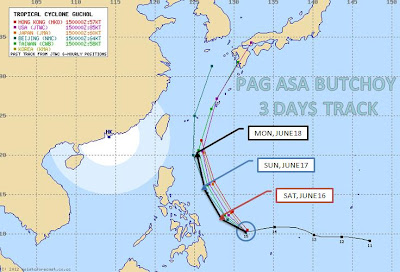
| Typhoon BUTCHOY Multiple Tracks (PAGASA and other Countries) for 3 Days |
The second typhoon next to AMBO for 2012 is spotted inside Philippine Area of Responsibility (PAR) 580 km East Northeast of Basco, Batanes with sustained winds of 160 kph and gustiness reaching 195 kph as of 2pm June 18, 2012.
Will it make to landfall and become a supertyphoon in the coming days?
Typhoon BUTCHOY 3 Days Track
Multiple tracks from typhoon center from other countries shows that Butchoy will make a curve path going to Okinawa Japan in Tuesday morning and will not make a landfall in the Philippines. PAGASA Butchoy forecast track is the same.
Coordinates: 22.7N 127.7E
Typhoon Diameter: 200 km
Sustained Winds: 160 kph
Gustiness: 195 kph
Movement: 24 kph North Northeast
Distance to Land: 580 km East Northeast of Basco, Batanes
Rain Volume: 15-25 mm/hr (Heavy Rain) within 500km diameter of typhoon
 |
| Typhoon CHEDENG (May 2011) closely resembles BUTCHOY track |
Interesting Facts:
Last Year (2011), exactly the same month of June, Tropical Depression "EGAY" and "FALCON" never make a landfall and Typhoon "CHEDENG" (May 2011) closely resembles BUTCHOY track.
Philippines is visited by 20 typhoons yearly and only 9 of them or 45% making a landfall. It is not only wind that is destructive but the rain volume that causes flooding and landslides to prone areas. So, we'd always better be prepared than making repair of the damages.
Source:
PAGASA
Typhoon2000
Related Articles
+ PAG ASA Most Advanced Doppler Radar is Operational in Catanduanes
+ Typhoon SENDONG - Philippine Most Deadliest Typhoon for 2011
+ Typhoon Ramon, Quiel and Pedring -The Inconvenient Truth of Philippine Typhoons
Comments
Post a Comment