Month of July and August are peak of "HABAGAT SEASON" every year in the Philippines. Although typhoons do not directly make a landfall, its presence inside Philippine Area of Responsibility (PAR), usually at Northeast of Batanes (120-125N, 20-25E) are making indirect effect by enhancing Southwest Monsoon (HABAGAT) causing havoc in Metro Manila and near provinces.
It's 3 am, August 19, 2013 in the morning, heavy rains woke me up and I decided to look outside if it is flooding, I remember "HABAGAT 2012", it's almost the same scenario.
A few hours ago, before I slept, PAGASA issued a RED Rainfall warning in Metro Manila and near provinces including Laguna - it means torrential rain greater than 30mm per hour of rainfall volume that is most likely to last for 3 hours and everyone is advised to prepare to evacuate due to flooding especially those in low lying areas.
PAGASA 13th Typhoon "MARING" is currently enhancing "HABAGAT" causing heavy to torrential rains in parts of Luzon and start flooding some portions of Metro Manila, Cavite and Laguna (early evening of August 18, 2013).
Rainfall Warning System is PAGASA's latest alert system beside Public Storm Warning Signal system. It started when "HABAGAT 2012" flooded Metro Manila enhanced by typhoon "HAIKUI" last August 2012.
I slept back at 3:30 am and woke up at 5 am and flooding is everywhere (in front of my house and even on TV news). I ask myself? Do weather have patterns and repeated every year? Is this a climate change effect?
Both HABAGAT happened at the same month of August 2012 and 2013 with the same weather disturbance at Northeast of Batanes. Lets compare the rainfall volume of the two.
PAGASA HABAGAT 2013 vs HABAGAT 2012 Rainfall Volume Comparison
 |
| Rainfall Volume on PAGASA Sangley point in Cavite recorded a 2.25x higher compared to normal whole month of August causing flooding on Cavite-Laguna Area. |
1. PAGASA Sangley Point, Cavite
3 Days Rainfall Volume: 1,067.4mm (HABAGAT 2013), 787.8mm (HABAGAT 2012), 475.4mm (Normal Rainfall Volume for month of August)
 |
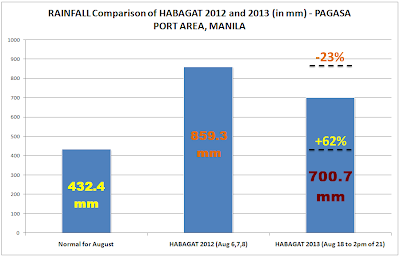
| Compared to HABAGAT 2012, HABAGAT 2013 Rainfall is 23% much lower but still Manila is flooded everywhere because it is almost 2x the normal Rainfall for whole month of August. |
2. PAGASA Port Area, Manila
3 Days Rainfall Volume: 700.7mm (HABAGAT 2013), 859.3mm (HABAGAT 2012), 432.4mm (Normal Rainfall Volume for month of August)
 |
| PAGASA Science Garden in Quezon City recorded 3 days HABAGAT 2013 Rainfall volume with the amount more than the whole month of August. |
3. PAGASA Science Garden, Quezon City
3 Days Rainfall Volume: 545.5mm (HABAGAT 2013), 1,007.4mm (HABAGAT 2012), 504mm (Normal Rainfall Volume for month of August)
Note:
HABAGAT 2013 is taken on August 18,19,20 and until 2pm of 21, 2013
HABAGAT 2012 is taken on August 6,7 and 8, 2012
Source:
GMA News
Related Articles:
+ PAGASA List of Typhoon Names for 2013, 2017 and 2021
+ PAGASA Typhoon PABLO Deaths and Damages - Deadliest in 2012
+ DOE Energy Plan for 2012-2030 - Aims to Mitigate Climate Change
+ DOST Project NOAH - Now Available on Mobile Android
+ EO26 NGP - PNOY Largest Reforestation Program
+ New PAGASA Rain Color Coded Warning Signal Alert System
+ PAGASA Habagat Brings 80% of ONDOY'S Rain Volume
+ How PAGASA, DOST Project NOAH Works? - A Review
+ PAGASA Most Advanced Doppler Radar is Operational in Catanduanes
+ Typhoon Sendong - Philippines Most Deadliest Typhoon for 2011

Comments
Post a Comment