 |
| PAGASA 24th Typhoon "YOLANDA" 3 Days Forecast Track making a Landfall at Guiuan, Eastern Samar and other parts of Visayas Region. |
PAGASA sighted Typhoon "HAIYAN/YOLANDA" (International Name/Local Name) inside PAR at 250 km East Southeast of Guiuan, Eastern Samar as of 11 pm November 7, 2013.
Previously, this weather disturbance was expected to enter PAR Thursday morning and will be called "YOLANDA" - the 24th typhoon to enter Philippine Area of Responsibility (PAR) for 2013.
It was forecasted to gain strength as it traverse PAR and high chance of becoming a supertyphoon (now already a supertyphoon - by other weather agencies) in the last few days.
PAGASA Supertyphoon HAIYAN/YOLANDA Forecast Track and Rain Volume
 |
| PAGASA "YOLANDA" MTSAT as of 11:30 pm, Nov. 7, 2013, eye is fast approaching the land mass of Visayas. |
Coordinates: 10.4N, 127.9E
Signal #4 (>185 kph winds)
Luzon: Masbate
Visayas: Northern Samar, Eastern Samar, Samar, Leyte and Southern Leyte, Biliran province, extreme Northern Cebu, Bantayan Island, Capiz, Aklan, Northern Antique and Northern Iloilo
Mindanao: NONE
Signal #3 (101-185 kph winds)
Luzon: Ticao Island, Sorsogon, Romblon and Calamian Group of Island
Visayas: Rest of Antique, Rest of Iloilo, Guimaras, Northern Negros Occidental, Northern Negros Oriental, Bohol, Northern Cebu, Cebu City and Camotes Island
Mindanao: Siargao Island and Dinagat province
Signal #2 (61-100 kph winds)
Luzon: Mindoro provinces, Marinduque, Albay, Extreme Northern Palawan and Burias Island
Visayas: Rest of Negros Occidental, Rest of Negros Oriental, Siquijor and Rest of Cebu
Mindanao: Camiguin, Surigao del Norte, Surigao del Sur and Agusan del Norte
Signal #1 (30-60 kph winds)
Luzon: Metro Manila, Bataan, Camarines Norte, Camarines Sur, Catanduanes, Southern Quezon, Laguna, Rizal, Cavite, Batangas, Lubang Island, Rest of Northern Palawan and Puerto Princesa
Visayas: NONE
Mindanao: Misamis Oriental and Agusan del Sur
 |
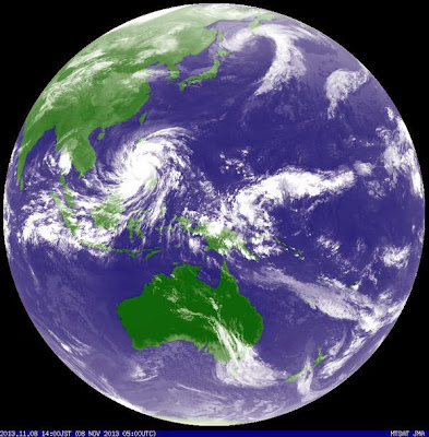
| Supertyphoon HAIYAN/YOLANDA as seen by Japan Meteorological Agency MTSAT Nov. 8, 2013 battering Visayas region and affecting the whole country of Philippines. |
Forecast Track:
(1) Landfall on Guiuan, Eastern Samar - Friday Morning
(2) Vicinity of Coron, Palawan - Friday Evening
(3) out of PAR - Saturday Evening
Strength: 225 kph near center
Gustiness: 260 kph
Possible Landfall: Guiuan E. Samar (Nov. 8, 2013, 5am), Leyte, Biliran, Northern Tip of Cebu, Iloilo, Capiz, Aklan, Romblon, Semirara Island, Southern part of Mindoro and Busuanga.
Movement: West Northwest at 39 kph
Distance to Land: 250 km East Southeast of Guiuan, Eastern Samar
Rainfall Volume: 10-30 mm/hr (heavy - intense) within 600 km diameter
Did you know? The strongest typhoon to hit Philippines (1947-2009) is "REMING/DURIAN" with wind speed of 320 kph hitting Virac, Catanduanes on Nov. 26 - Dec. 1, 2006.
Sea travel is risky over the seaboards of Northern Luzon and over Eastern seaboard of Central Luzon.
Everybody is advised to prepare in advanced. To monitor your weather and rain probability from time to time in your area, please visit PAGASA and DOST Project NOAH.
Updates: Supertyphoon "YOLANDA" had made six landfall on Nov. 8, 2013, (1) Guiuan, E. Samar at 5am (2) Talosa, Leyte at 7am, (3) Daanbantayan, Cebu at 10am, (4) Concepcion, Iloilo at 12 noon (5) Cuartero, Capiz at 1 pm (6) Busuanga, Palawan at 8 pm.
PAGASA typhoon "YOLANDA" is already out of PAR as of November 9, 2013 and threatening Vietnam and China.
As seen on television news, aftermath effect of "YOLANDA" is devastating. I experienced supertyphoon "ROSING" in 1995 at Virac, Catanduanes and all I can say "it's the same feeling of fear and faith".
Sources:
Typhoon2000
Top 20 Strongest Typhoons of the Philippines
Related Articles:
+ PAGASA HABAGAT 2013 vs HABAGAT 2012 Rainfall Volume Comparison
+ PAGASA List of Typhoon Names for 2013, 2017 and 2021
+ PAGASA Typhoon PABLO Deaths and Damages - Deadliest in 2012
+ DOE Energy Plan for 2012-2030 - Aims to Mitigate Climate Change
+ DOST Project NOAH - Now Available on Mobile Android
+ EO26 NGP - PNOY 1.5 Billion Trees Reforestation Program
+ New PAGASA Rain Color Coded Warning Signal Alert System
+ PAGASA Habagat Brings 80% of ONDOY'S Rain Volume
+ PAGASA Most Advanced Doppler Radar is Operational in Catanduanes
+ Typhoon Sendong - Philippines Most Deadliest Typhoon for 2011
Comments
Post a Comment